After the 3-day southern gale started to abate, we left Naoussa port at
the north of PAROS, where we’d taken refuge, and headed for the harbour of the island
of NAXOS, overlooked by the Chora (the capital) – also confusingly called Naxos.

Route
to 8 May 2019, plus that covered in this Blog
NAXOS
As we approached the port, we re-learnt, the hard way, that it is essential
to look aft regularly since fast hydrofoil ferry skippers enjoy creeping up on
yachts at speed and then hooting.

View
west over the Chora and Kastro (fort) of Naxos town showing the yacht harbour
in the foreground and the ferry docks to the right.
Naxos is a major ferry port – particularly
for fast jet ferries
This finally convinced us of the value (in Greece) of our new mobile AIS
[Automatic Identification System] app, which allowed us to identify clearly
problematic ferries and to call them up by name on the VHF when there was any
doubt as to their intentions. It was
very effective since we saw them immediately change direction, where we had
right of way, albeit that some deigned not to answer. However, they knew and they also knew that
everybody else within twenty miles knew that they had been called and therefore
had no excuse for not taking the correct action as can be the practice with
some cowboy skippers.

AIS
mobile app gives a photo of the vessel, with its name, speed, direction etc.
The town’s port looked full when we arrived. Even so, the Harbour Master (Nikolas) found
us an empty berth among local boats, which we were just able to squeeze into. We even reversed in stern-to and used our
passerelle on our new aft fitment – for the first time. At 12€ per night including electricity and
water, we were very happy with our lot – especially as we’d been advised that
it would be most unlikely that we would get in,
‘it was not possible to book in advance’ (but it is, we now know) and
that 'its protection was inadequate particularly with regard to ferry wash' (which again it wasn’t!).

Yacht
harbour – full of yachts
A causeway built to protect the harbour from northerly winds connects
Naxos town with the small islet of Palatia at the mouth of the port’s
entrance. A colossal free-standing
marble door frame called Portara is all that remains vertical there of the
Temple of Apollo, once one of the largest temples in Greece.

Temple
of Apollo and causeway viewed from Naxos town
On arrival in the port, one could be easily persuaded that the busy
tourist-orientated waterfront was a reflection of the town itself and indeed of
the island as a whole. One could not be more wrong. There is more ‘life’ and interest in the back
streets of the old town (Bourgo) and labyrinth of Venetian-era mansions,
fortifications, post-Byzantine churches and secluded lanes in the Kastro (fort)
which looms over the town and port than on the waterfront.

Waterfront
and Kastro as seen from ID’s
berth. (Sailing aficionados will have
noted that ID is stern-to using our
passerelle off the aft of the boat.)
NAXOS is the loftiest, largest and, it is generally considered, most
magnificent of the Cyclades Islands.

Google
Earth NAXOS
The Naxians were initially disdainful of tourism since, like Crete, the
island was able to support itself through
agriculture and fishing. That view is
changing. However, the island has
benefited from the lessons learned elsewhere and hence has had the opportunity
to manage its tourist industry better. To
date, the impact of tourism has been relatively benign and the island’s natural
character has not been seriously damaged. Talk of a significantly extended
ferry quay for cruise liners could change that!
Apart from the island’s main Chora, NAXOS’s
principal attractions have always rested in its golden sandy beaches, verdant
mountainous hinterland, unspoilt villages, and coastal scenery.
We remembered well that historically NAXOS’s roads could be positively lethal. They have now been dramatically upgraded as
part of the EU’s contribution to infrastructure, thereby making NAXOS’s beaches
and interior more accessible to Naxians and visitors.
The coastline south of Naxos town is a west-facing strip, in the lee of
the meltemi wind, unequalled in the Aegean, which runs for kilometres between
headlands and coves in a succession of excellent golden sandy beaches. A coastal road runs parallel with the
beaches, connecting the scattered houses and small holiday complexes situated
along the strand. Developments around
the beaches are generally architecturally in keeping with the environment of
the island.

Ay
Anna beach and nearby village
NAXOS’s attraction has, however, always rested in its mountainous
interior, where a rural Greek atmosphere prevails in the villages. Farming is a vital part of the economy. In particular, NAXOS is known for its wine,
cheese and Kitron liqueur (similar to Italian Limoncello).

An
array of Naxian cheese in a small supermarket in Naxos

Helen sampling
Kitron liqueur in the distillery at Chalki
The winding mountain tarmac roads connect a succession of traditional villages. Four are of particular interest and
attraction:
Chalki, the former capital of the island, is a vivid
reflection of historic NAXOS with handsome facades of old villas and tower
houses, a legacy of its wealthy past.

Lunch
at an attractive open-air taverna in main square in Chalki
Filoti, situated on the slopes of Mt Zeus, at 1004 metres
the highest mountain in the Cyclades, is the region’s largest village.

Filoti
village on the slopes of Mt Zeus
Apirathos is a rugged village founded by Cretan refugees who
to this day speak among themselves in their own form of Greek. The village’s
streets are paved in marble from the nearby mines at Kinidaros.

Blocks
of marble, resembling chunks of feta cheese,
awaiting processing at the factory
in Kinidaros
Koronas is the highest village on the island. It marks the start of the steep descent to
the port and village of Apollanas.
The small fishing port, now resort, and anchorage of Apollonas are at
the extreme northeast tip of the island.
A huge 6th-century BC statue (kouros)
lies on the hillside above the village, apparently abandoned in the quarry when
its marble cracked. When we stayed in
Apollanas in 1989 it was merely a small fishing village with a few small
buildings. It has expanded significantly
since then, but fortunately does not appear to have lost any of its natural
charm.

Apollanas
village and port with a colossal abandoned kouros
(statue) in the foreground

Celebrating
our return to Apollanas with Greek coffee and baklava
in the same taverna we’d
eaten at 30 years ago
The Temple of Demeter is the most noteworthy building on NAX0S, outside
the Chora. It is situated 3 kilometres south of the hamlet of Ano Sangri. Constructed
around 530 BC on a low hill at the head of a fertile valley, the temple’s
importance is said to lie in its unique architecture, in that it had a square
floor plan with five columns and thin marble roof tiles that allowed diffused
light into the interior.

The
Temple of Demeter, the most noteworthy ancient ruin in Naxos
After a postponement of the new Greek Cruising Tax (TEPAI) from 2 April,
it formally came into force on 9 May.
There then followed a flurry of posts on the cruisers’ nets on the
subject – much of it incorrect and alarmist.
In brief, instructions for paying the cruising tax are available on line
and in English. One has to provide information on oneself and the vessel and
obtain through their website a 20-digit e-code and IBAN number, armed with
which one can either instruct one’s bank to pay AADE (Ministry of Finance?) by bank
transfer or print out the form containing the e-code and pay to the Port Police
or at a bank, in cash, ensuring one obtains a stamped receipt. Having paid on line, in our case with a currency card to avoid bank charges, we confirmed that our payment had been accepted by signing back into the TEPAI website after a couple of days and checking in the Payment Section that it said 'PAID' (in Greek!). One is advised to take a copy of this confirmation and keep it with the boat documents, since it is understood that the Port Police are already checking if people have paid.
Being already in the water on the day the tax was implemented, we had
ten days’ grace in which to register and pay.
One does not have to pay the tax for any complete month in which one’s
boat is out of the water. One has,
however, to pay for a full month even if the boat is in the water for only one
day in that month. (It’s 33€ per month
for our 37ft [11.4 m] boat. Once a vessel
is over 12 metres, the cost rockets. For example, a 48ft boat [14.7m] has to pay 120€ per month) Hence, leaving a boat in the water in a marina
can now incur an additional cost.
Launching and lift-out dates also become of increasing importance. We, for instance, will be lifting out on 30
June rather than paying for all of July when we’d only have been in the water
for one or two days that month!
DHINOUSSA
We got up early and left NAXOS soon after dawn to ensure we got to and
around the northern end of the island before any (unexpected) northerly wind
blew up – often the case even it’s not forecast. As it happened, it didn’t! This time the forecast of negligible wind was
correct and we ended up motoring all the way.

There
was no wind so we motor-sailed in calm seas down the east coast of NAXOS
DHINOUSSA, our target destination, rises steeply out of the sea some ten
miles off the wilder and mainly uninhabited east coast of NAXOS. It is the second largest but least visited of
the four inhabited islands of the Little Cyclades.

Google
Earth DHINOUSSA

Our
route in and out of the LITTLE CYCLADES Islands
Compared with the other islands it is a bit out on a limb. It isn’t a convenient route or stop for
ferries, hence it gets fewer visits – except in the summer. Having said that, two ferries a day isn’t
bad.

It took the ferry only five minutes to dock on and then leave the new EU quay at
DHINOUSSA watched by the entire population of the village. All 50 of them!
In high season (July and August) the island is swamped by day-trippers
and holiday makers; in particular, Greeks, property owners, campers and
Northern European naturists.

The bay
of Kendros, on the other side of our headland in Ay Stavros port (also known as
Dhinoussa as is often the custom in Greek islands), is popular with campers and
naturists
Out of season, the island attracts those looking to enjoy a tranquil
week or two in a traditional Greek environment with some good walks, excellent
beaches and crystal-clear water in what is undoubtedly one of the most
beautiful and unspoilt islands in the Aegean.

Livadi
bay and small anchorage

Crystal-clear
water off the town’s beach
For good measure, the island is blessed with five excellent sandy
beaches, a number of small accessible coves, an attractive
village/ferry/fishing port, two small hamlets and, thanks to EU financing, a
new tarmac road on the south and east coast, that links them up. Traditional mule trails in the north and
west of the island provide a challenge and fantastic views for hikers.

The
colourful, old and active fishing port of Ay Stavros, off which we anchored

The
new tarmac road linking the port with Kalioritissa.
While no doubt appreciated by the half dozen inhabitants who own a car, it has been laid over much of the ancient and scenic mule trail
While no doubt appreciated by the half dozen inhabitants who own a car, it has been laid over much of the ancient and scenic mule trail
Each of the five bays makes an excellent anchorage in the right wind
conditions – although none is suitable in a gale from the south through to
south east.

Kalioritissa
hamlet and bay in the north-east corner of the island, viewed at the base of
the mountain trail on our hike around the island – a particularly
well-protected anchorage but not much ashore. The ‘shop’, for example, is in
somebody’s house
We anchored off the town beach of Ay Stavros. While only tenable in good weather, it was as
attractive a town anchorage as we’ve been to in the Aegean.

ID at anchor off Ay Stavros town beach

Part of
the town and beach seen from ID’s
anchorage

Helen
rowing ashore. The dinghy's wheels are
enormously helpful when pulling it up a beach, particularly when the engine is
on board
Even Mike was finally tempted to swim in the crystal-clear waters of the
bay – without complaining (much)! H is
swimming regularly and says the water is now much warmer than Calshot.

Mike
swimming off the boat
The island offers five excellent coastal/inland walks that give
outstanding views of both DHINOUSSA and its neighbours – up to 30 miles away.

Looking
down at the north-west corner of the island with NAXOS in the background
We ignored local advice and knackered ourselves on the longest and most
difficult hike along the south and east coast to Kaliriotissa and back to Ag
Stavros on the old mule trail over Mt Papas (385 metres).

On our
way down the mountain, easier walking
than the much steeper trail on the way up from
Kalioritissa
Having left early, we just got back in time for a late (3 pm) lunch in
Captain George’s Restaurant, which, together with one other overlooking the bay,
appeared to be well patronised each night.
We treated ourselves to goat slowly braised in an aromatic red wine
sauce and a litre of wine (between us, that is). Quite the best goat meal we’ve had in
Greece. For Mike this was only his
second drink since New Year’s Eve – having now lost his targeted two stone in
weight. Not surprisingly, since he had
his ‘fair share’ of the wine, on return to the boat he had a ‘short’ siesta and
woke up next morning. Clearly, he is out
of training!

Captain
George’s Restaurant
KOUFOUNISSIA
We’d already dived and checked, so we knew that our anchor was wedged
firmly under a rock. We were conscious
that while we were securely anchored, we could have difficulty extracting the
anchor when we left. Therefore, when weighing anchor on departure we did so
with an element of trepidation. Fortunately, we were able to drive it out (on
the second attempt).
Thereafter we simply motored south in negligible wind to the island of
KOUFOUNISSIA, the collective name for the two low-lying islands of ANO (Upper)
and KATO (Lower) KOUFOUNISSIA – although these days, and in this Blog, the name
is generally taken to mean the former.

Google
Earth showing both Ano and Kato Koufounissia
ANO KOUFOUNISSIA is the principal of the two islands, its companion
being little more than a large barren reef rising ten metres above sea level
and used simply for grazing goats.
Having said that, it actually has a quay, some tarmac roads, a church,
good beaches and in the summer a taverna with a great reputation. Hence it attracts day trippers in the high
season – although it has no permanent inhabitants.
We moored in the new EU-financed harbour recently built around the ferry
port dock, below the village of Koufounissia itself at the south of the
island. The harbour entrance is only 15
metres wide and rock ballast on either side further restricts the usable
channel for keeled yachts to only 5 metres.
The water was so clear, however, that Helen was able to con us through
the entrance without undue difficulty.

Koufounissia
harbour with its narrow entrance
On arrival we were directed to a berth on the north quay by the ‘harbour
master’. Once we were moored, he advised
us that it would cost us 15€ cash if we stayed for two nights. Sounded good value until we asked (before
paying) for a written receipt. At that
stage the supposed ‘harbour master’ became indignant and then went through what
we now presume is his usual routine:
‘Receipts are only issued in high season’; ‘he would bring one
tomorrow’; ‘if we didn’t settle up immediately, we would have to leave’; ‘he
was trying to help us by offering us a cash deal since the price with a receipt
was 40€ per night’. We briefly conferred
and confirmed our joint suspicions, after which Mike told our new ‘friend’ –
‘no official receipt for us, no money for you’.
The ‘harbour master’ then offered to reduce our ‘fee’ to 10€ for
‘finding us a space and taking our lines’ – which we hadn’t needed him to do.
This he then reduced to 3€ - ‘as a goodwill gesture’ – at which stage Mike told
him in Anglo Saxon, which he clearly understood, to ‘go away’. Being the professional he was, this he did
without apparent rancour. (Win some, lose some!) A charter skipper who came in later confirmed
that the guy cons most new arrivals and that the port was actually FREE since
it had not yet officially opened for the year.
This might well explain why the local fishing boats were hogging almost
every space on the quay.
This being Greece, it comes as no surprise that the smallest of the four
inhabited islands of the Little Cyclades is the most populated and indeed
accommodates the greatest number of tourists each year.

Google Earth ANO KOUFOUNISSIA
It has in fact become a popular place to visit with its unspoilt gently
sloping golden sandy beaches, plentiful beachside tavernas and good accommodation,
all within easy access of the port by road or track. In July and August its infrastructure in
terms of accommodation, restaurants and tavernas are said to cope adequately as
they expand in size each year. In
consequence prices can be negotiated out of season when supply exceeds
demand.
The island has a substantial fishing fleet normally based in the fishing
port at Parianos, some mile north of the ferry port and village and in the
summer on buoys off the excellent town beach in Koufounissia bay. (Out of season they use the ‘yacht marina’!)

Koufounissia
town beach with visitors’ studios and
other forms of accommodation in the background
To be fair, the fishermen appear to be a hard-working lot. Not only do they provide colour and
atmosphere to the island but they also keep the local community and visitors well
fed. Fish is always the first item on a
taverna’s menu. While there is room for
visiting yachts to anchor in the bay off the town beach, there is no room in
the fishing port other than possibly as a port of refuge, probably rafted on a
fishing boat.

Fishing
port of Parianos, viewed from local fishermen’s shoreside taverna
The fishing fleet is supported by a very active, small, interesting and
colourful traditional boatyard situated between the two ports at the south of
the island.

Traditional
boatyard which supports the fishing fleet
Ferry connections are as good as in any other island in the group. In addition, it is easily accessible for day
trippers from NAXOS.
The island’s only
village stands on a gentle hill behind the harbour. Its old attractive ‘main street’ is too narrow to admit cars.

Koufounissia
chora

The
chora’s ‘Main Street’ is too narrow to admit cars
Most ‘new-build’ is either holiday homes for seasonal residents, visitors’
rooms, apartments, studios or hotels – not for the locals who are already well
established. There is a lot of new-build
taking place both around the town and behind the beaches.

Prefabricated
cube buildings being installed behind one of the island’s beaches
The truth is that sightseeing does not feature in most visitors’
itinerary. The majority of holiday makers and day trippers don’t come to
KOUFOUNISSIA for much other than the beaches, good accommodation and excellent
tavernas.

One of
the wider beaches on the island

Visitors’
accommodation and tavernas now back most beaches
Apart from the larger easily accessible sandy bays and beaches, there is
a number of less accessible coves where latter-day troglodytes take up
residence during the summer. While
theoretically banned, the islanders seem pretty relaxed about nudity. Two beaches are de facto ‘nudist’, very much
thanks to their relative isolation. As
is normal, those who should not, do!

A
troglodyte cove
Increasingly popular with wind surfers is the longer, wilder, sand-duned
east coast bay at Pori, considered the best beach on the island. This is a popular place for yachts to anchor since
it is both a scenic location and gives reasonably good protection from the
Meltemi.

Pori
bay, beach and anchorage
Following our coastal walk around the island, we rewarded ourselves with
lunch at Capetan Nicolas’s taverna: the stuffed tomatoes, peppers and aubergine
‘slipper’ were delicious.

Capetan
Nicolas’s taverna is very pleasantly located overlooking the boatyard
KAROS
East of Koufounissia the island of KAROS can be seen, with its rugged
mountains and steep seacliffs. It is
uninhabited, even though it is the largest of the Little Cylades islands.

KAROS
viewed from Koufounissia harbour
Once the dominant member of the Little Cyclades group, it became the spiritual home, rather like Delos is for the Cyclades as a whole, of early
Cycladic culture and a burial ground for the Little Cyclades inhabitants. Hence
it has become an important source of archaeological information and is still an
important and active site.
Casual sightseeing is not encouraged and indeed there is only one (in
good weather) anchorage in the island.
It is possible to hire an ‘official’ caique in Koufounissia to go on an
‘official’ tour, but it is expensive and we didn’t go.
ANTIPAROS
Having completed our exploration of the inhabited islands of the Little
Cylades, we began to move towards Mykonos where we are due to pick up friends
at the weekend. We decided to sail via
ANTIPAROS since we had the time and had not yet been there.
The relatively low-lying island of ANTIPAROS (as compared with its
immediate neighbour) lies off the southwest coast of PAROS, separated therefrom
at the north by a very narrow and shallow channel. DESPOTICO and STRONGILO, the
two islets to the south of ANTIPAROS,
while they may have buildings and even tavernas on them, are not
permanently inhabited. The former, however, is said to have a reasonable
meltemi-proof anchorage on its south coast.

Google
Earth ANTIPAROS
Under a particularly cloudy sky we sailed the 30 miles due west, from
KOUFOUNISSIA to the large bay of Dhespotico between ANTIPAROS and DHESPOTICO – an
excellent if not outstanding all-weather anchorage well protected from the
elements and with good holding. Not
surprising therefore that in the sixteenth century it was used for R&R by
pirate galleons.

Dhespotico
anchorage
In the last ten years EU-financed tarmac roads between the north and
south ends of the island, along the east coast, have helped to open up those
areas of the coast to developers of holiday villas, small hotels and
tavernas. Looking at the preparatory grid
of earthen tracks carved out by the developers behind Ay Georgios on the south
coast, there is clearly much more to come.

Development
behind Ay Georgios at south end of PAROS
Having received, admittedly as previously scheduled, the proof of the
OCC quarterly newsletter from Jeremy Firth, the editor, in Tasmania, and with
friends arriving in two days’ time, Helen accepted her lot and ended up
proofreading all day and indeed into the night.
Such voluntary work never arrives at a convenient time!


Copy of
front page of OCC March 2019 Newsletter [ã OCC
Org]
Meanwhile, Mike motored ashore by dinghy, given the size of the bay, and
walked to the ot her end of the island, to the town of Antiparos and – since the bus wasn't running that day –back
again! The town and the pleasure and ferry
boat port form the centre of the island’s life, at least before east-coast
ribbon and more extensive property development around Ay Georgios in the
south. Arguably it still does.


Town, port and anchorage of Antiparos
The town’s quays are, however, completely dominated by local,
pleasure and ferry boats and much of the bay is too shallow to anchor in, while
other spaces are either limited or ‘said to get in the way’ of ferry traffic
‘which has priority’. On the positive
side, it is possible to anchor and the town has good facilities. While
there, Mike enjoyed an excellent lunch – meatballs with potatoes and carrots in
a lemon sauce, washed down with a litre of refreshing water!
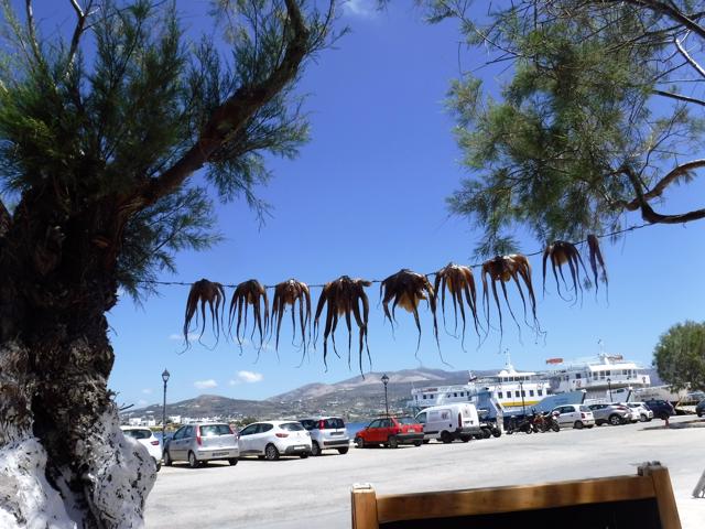
Locally
caught octopus hanging up to ‘season’
outside the portside taverna where Mike had lunch
outside the portside taverna where Mike had lunch
Apart from tavernas, bars and boutiques, the principal attraction for
visitors to both the town and island is its excellent beaches which accommodate
the ‘needs’ of families, surfers and nudists.

Antiparos
town’s local beach looked inviting with its tamarisk-shaded sand and beach bar
Sufficient remnants exist for visitors to study and understand the
layout of the town’s Kastro, which is well worth visiting. Based on a Venetian
design, the fort’s walls were made up of the population’s houses which had
thick outer walls and whose windows and doors faced only into the courtyard.
The small, stone Gothic archway, which was the sole entrance to the fort, still
stands. Even today, it is the only way
into the courtyard other than through the private houses of the fort where the
owners have made new entrances in the outer walls. The base of the fort’s observation tower at
the centre of the courtyard still stands.

The
14th-century entrance arch into the fort still stands
The island’s once (arguably still) world-famous caves are within easy
walking distance of Ay Georgios, off which we anchored. They remain mightily impressive and are well
worth visiting despite their modern narrow concrete walkways and electric
lighting (Health & Safety!) and the looting and damage to stalagmites and
stalactites. The walls and indeed the
‘mites’ and ‘tites’ are covered in historic graffiti dating back over 300 years
– the most notable vandals being King Otho of Greece and Lord Byron!

One of
the Caves of Antiparos
MYKONOS
With a 50-mile passage ahead of us we left early for the MYKONOS area –
against a light headwind but on a relatively calm sea. Fortunately we’d anticipated that while not
forecast, a northerly wind could arise and it took 12 hours to reach MYKONOS,
as compared with the ten hours expected.
Even so we did make it and anchored in Korfus Bay south of Mykonos and
its old harbour where yachts are no longer allowed to moor.
We await the arrival of our friends Max and Sue Walker tomorrow evening.
Amazing images, a wonderful blog
ReplyDeleteNo need for us to even dream of sailing in the area, you have done it for us. Lovely pictures, I'm sure you are having a great time. Regards Geoff Lloyd
ReplyDeleteFabulous - and invaluable. It even makes me wonder (sometimes) why I am still doing the day job! Keep safe, and happy sailing!
ReplyDeleteHoliday Villas in Antiparos Greece
ReplyDeleteAre you Looking for the best Luxury Villa Rentals in Antiparos, and Holiday Villas in Antiparos Greece? Villa Despotiko offer Luxury villas rent with affordable price.
Most of the blogs pretend themselves as most usable and updated blogs with new information but sometime truth might different. I want to share some facts related to this subject which will help people to enhance their skills.
ReplyDeleteYacht Charter Mykonos to Santorini