We are now moored in Nafplio at the north of the Argolic Gulf of the Peloponnese. Since the posting of our last Blog (#8), we have cruised the east coast of the Peloponnisos from POROS where we first made landfall on our passage west on this cruise from LEROS.

The giant peninsula of the
Peloponnisos takes its Greek name of Peloponnisos from the name of the
legendary hero Pelops, plus the Greek word for island ‘nisos’. In truth it is
only an ‘honorary’ island, since it was not until 1893 that the peninsula was
separated from the rest of the mainland by the construction of the Corinth
Canal through the Corinth Isthmus.

Google Earth©
view of the Peloponnisos ‘island’

Postcard of the bridges over the Corinth Canal
POROS
We initially anchored, after
our passage from LEROS, behind the island of POROS off the north-east coast of
the Peloponnisos as it offered excellent shelter from the strong northerly
winds that were forecast.

Google Map© view
of POROS with its harbour, quays and range of excellent anchorages

Monastery Bay
where we first anchored, with the 18th-century monastery from
which
the bay takes its name. It has one of the island’s best beaches,
backed by the Monastery’s olive groves
backed by the Monastery’s olive groves
During our ‘enforced’ 3-day
stay behind POROS, we explored the harbour and, when anchored, we had time to
research on- line and in our various travel guides and pilot books the
Peloponnisos – the east coast in
particular.

Anchored in
Neorion Bay at sunset
The truth is that while we
strategically plan our cruises in advance, we prefer to research and plan in
detail once we’re actually underway.
We’ve found that micro-planning in the UK never works out for us once we
get to sea! The weather, locally
acquired up-to-date knowledge and changing objectives invariably alter the
best-laid plans.
POROS (which is actually made
up of two islands, Sphairia to the south and Kalavria to the north) takes its
modern ‘composite’ name from the narrow shallow strait that separates the town of
Poros from Peloponnisos, Poros meaning passage.

At anchor in
‘Canal’ Bay, near the entrance to the ultra-narrow, shallow and short canal
(local gent sunning himself beside it) that bisects the two parts of the
island
In fact, the Poros Strait and
town are the focus of activity on the island, with ribbon development along its
southern shores, where the majority of the population live. The significantly larger northern island of Kalavria is a heavily wooded hinterland. It offers good
walking opportunities and some better beaches; hence a number of holiday
complexes have more recently started to be developed there.

Poros town and quay with charter fleets ‘parked’ in the
foreground

Narrow, shallow strait between POROS and Peloponnisos’s mainland
town and ferry port of Galatas
HYDRA
(YDRA) GULF
The next stage of our cruise
covered our passage from POROS through the Gulf of Hydra to Porto Cheli at the
mouth of the Argolic Gulf. The area has
a wide range of anchorages and three large ports: Hydra, Ermioni and
Spetses. None of them, however, provides
the all-round shelter of Poros Bay or Porto Cheli, both of which are excellent
Medicane [Mediterranean Hurricane] holes.

Google Map© of
Gulf of Hydra showing principal ports,
anchorages and our route through it
anchorages and our route through it
HYDRA
The long narrow island of
HYDRA runs parallel to the Peloponnisos coast and borders the south side of the
Gulf. It is mountainous and barren.
Today most of the population of 3,000 live in or around the port of Hydra
itself. Amazingly, in 1820 the island
was home to twenty-eight thousand people.

Google Earth©
view of Hydra town and port
During its five centuries
under Ottoman rule the island prospered as a consequence of its ship-building
skills, a large mercantile fleet (150 ships) and its capacity and willingness
to train and supply sailors to the Turkish fleet – in return for lower taxes!
In 1821, however, HYDRA and
SPETSES were the first Greek islands to pledge their fleets to the Greek cause
for Independence. Admiral Miaoulis,
subsequently the war-time commander of the Greek fleet, was himself a Hydriot,
as was Georgios Koundouriotis, the first president of the new Greek state. It is now generally held that Greece would
not have won the War of Independence without the fleets of HYDRA and SPETSES.

Fortifications
at the entrance to Hydra harbour, with the statue of Admiral Miaoulis
The island and its fleet never
recovered from its war effort and both declined in importance throughout the
rest of the century. However, in the early twentieth century, Hydra became a
fashionable resort for the ‘rich and famous’ and later during the fifties and
sixties became home to communes of artists.
There are many large, imposing buildings in the town, which reflect the
island’s past prosperity. Today, regrettably the town can be completely
inundated with day trippers from Athens – the absence of wheeled vehicles, let
alone motor vehicles, means they cannot easily disperse elsewhere on the
island.

Hydra town’s
imposing architecture around its port
When we first visited, the
port was our idea of hell – and we are well out of season! Boats were moored
three to four deep off the quaysides; the holding was said to be poor and
crossed anchors are, we understand, a fact of life. In strong northerly winds it
suffers severe swell and is reported to become like a giant washing machine.

Chaos in Hydra
port when we arrived

Even more chaos
in Hydra port wherever we looked
On our first visit, since it
was getting dark we simply stuck our nose into the port, looked around and
left! That night, we anchored in Mandraki Bay, half a mile east of the port.
The anchorage is deep and in consequence we really should have added rope to
the 70 metres of anchor chain we carry.
Fortunately the weather was benign overnight.

Mandraki
anchorage
Next morning, out of
curiosity, we ventured back to the harbour. Most of the charter and Athenian
yachts had left after the weekend and the day trippers had not yet arrived by
ferry. In the sunlight with tiers of grey stone mansions and humbler
whitewashed, red-tiled houses climbing up the hillside from the picture-perfect
horseshoe harbour, it was a different place.

Amphitheatre of
houses surrounding Hydra port
ERMIONI
We arrived in Ermioni just
after the Ochi Day parade had finished and families had assembled in the
quayside tavernas for lunch. In consequence, our first impression was of a very
busy and cheerful community, which indeed it was. Ochi Day is celebrated on 28 October each
year, to commemorate the Greek Prime Minister Ioannis Metaxas saying no to
Mussolini’s ‘request’ to station Italian troops in Greece.

War Memorial in
Ermioni with wreaths of olive branches at the base, following the town’s Ochi
Day parade that morning
Ermioni is located on the
north-west corner of the Gulf of Hydra.
It was traditionally a shipbuilding centre which contributed
significantly in the 1820s to the Greek War of Independence. Since then, its
shipbuilding industry has declined and today the fertile region around the town
is better known for its olives, citrus fruit and pomegranates. While until recently the village has been
relatively untouched by tourism, this situation is changing due to its
location, improved road access, beaches and micro-climate. It remains very Greek.

Ermioni from the
air
As we tied up on the quay on
arrival, we were hailed by another yacht that was mooring at the same
time. By sheer chance it was Koen Lindner
on his yacht Misty. We met him
and his partner Jacqui in Skopelos in November last year. This time he was organising a rally for next
May and was going off to bury ‘treasure’!
(The rest of the anchorage, said to be full in the summer, was
completely empty.)

With Koen Lindner
on Ermioni quay – he was about to bury treasure!

Island Drifter (ID) and Misty on Ermioni quay
Ermioni saddles the Kastri
peninsula and therefore provides good all-round shelter as yachts can either
anchor or moor on either side of the peninsula depending on wind direction.

Google Earth©
view of Ermioni
ARGOLIC
GULF
The Argolic Gulf reaches on
its east side from Aimilianos cape in the south to the large city and port of
Navplio in the north. It is surrounded by high mountains, except at the
northern head of the Gulf where there is the flat plain of Argos. The Parnon range of mountains on the west
side of the Gulf continues right down the Peloponnisos to Cape Maleas at the
south of the peninsula, well into the Aegean.

Google Map© of
Argolic Gulf showing our route and anchorage options
The prevailing wind in the
Argolic Gulf is a south-easterly sea breeze known as the Bouka Doura. After a
calm morning, this breeze gets up during the midday and gains in strength
during the afternoon, before dropping in the evening. Below the Argolic Gulf, on the southern part
of the Peloponnisos the northerly meltemi winds hold sway.
On our way into the Argolic
Gulf, we anchored overnight west of Amilianios point in a pleasant sandy bay
overlooked by some very expensive-looking estates.

Helen enjoying the evening sun in
‘Amilianios’ Bay
SPETSES
A popular, upmarket escape for
wealthy Athenians, SPETSES had a brief vogue as a package-holiday destination,
largely thanks to John Fowles, who lived there in the 1950s and used the place,
thinly disguised, as the setting for his cult novel The Magus. The
island, however, never developed a mass tourist infrastructure.

Google Earth©
view of SPETSES
Today Spetses is the largest
town within the Peloponnese islands, with apartments and villas spreading for
several kilometres along its north coast.
The rest of the island remains relatively uninhabited, with pine forests
inland and numerous excellent small beaches.

North coast of
SPETSES showing ribbon development spreading out from the town
The island shares with HYDRA a
history of late 18th-century mercantile development and prosperity
and a leading role in the War of Independence, which made its foremost citizens
the autocrats of the new Greek State.
Many fine old houses and public buildings survive among more modern
buildings.

Typical street
scene in Spetses
Although most cars are banned from
the town, they have been replaced by thousands of scooters and mopeds. For most visitors, shopping, eating and
drinking are the principal attractions of SPETSES. Even so, it is an enjoyable
place to wander around, with its old houses and gardens scattered along the
narrow streets.

Spetses’
attractive older buildings
The local heroine
Laskarina Bouboulina, a wealthy widow,
commanded her own fleet in the War of Independence and her statue is located
centre stage on the promenade that runs around the town.

Statue of Laskarina
Bouboulina, located near to where she lived
and the museum named after her
Baltiza Creek, where we
stopped, has several yards with caiques and Spetsiot boats, which are said to
be among the best in Greece. The old harbour at the head of the creek is
particularly attractive. Tim Severin had his replica galley built there for his
voyages tracing the routes of Jason and the Argonauts and Odysseus on his way
home from the Trojan Wars.

Looking out to
sea from the root of the Old Harbour which was full of local boats

A traditional
boatyard in Baltiza Creek, Spetses
Facilities for visiting yachts
exist but are limited and don’t satisfy demand even with the small additional
mole that has been added off Dapia. On
our first visit we simply could not find a berth. When we arrived mid-morning the next day,
there was no shortage of space – possibly because the charter fleets were
coming to the end of their season or it was change-over day.

ID on quay. Most of the fishing boats with whom we’d shared the quay left at dawn
Mike particularly wanted to
sample the fish dish peculiar to the island – ‘Fish a la Spetsiosa’, a
casserole of fish, tomatoes and green pepper covered in cheese. Having identified what we thought was a handy
taverna that served this dish, we ended up walking out once we’d seen the
astronomic prices on the menu. Had we
looked the place up in advance on Tripadvisor, we’d have been forewarned that
(while it is in a great waterside location) it was ‘overpriced, overhyped and
staffed by surly waiters – a complete rip-off to milk those with more money
than sense!’.

Great location;
astronomic prices!
Porto Cheli
Porto Cheli at the mouth of
the Argolic Gulf provides outstanding all-round shelter, being protected by
both the Peloponnese mainland and the island of SPETSES. It has a range of good anchorages, a long,
deep ex-NATO quay and a new floating marina. The town is pleasant, with a large
supermarket and, to Helen’s delight, a laundry.
Frank’s boatyard, which we were looking for, appears to have closed.

Google Earth©
overview showing Porto Cheli on the right
and a salt water lagoon on the left
and a salt water lagoon on the left

Porto Cheli’s
ex-NATO quay

Google Earth©
view of the new marina, which is still in the process of completion
– although
it is accepting visiting yachts

Dinghy loaded
with provisions for the week
We enjoyed a long weekend
there, anchored outside the marina pontoons, and watched the Rugby World Cup
semi-finals. We even placed a bet (unprecented!) on the England v New Zealand
match and ended up with a £650 profit, a small part of which was immediately
spent on a celebratory lunch!
Regrettably we lost our £200 stake the next day when supporting Wales
against South Africa.

England face off
the All Blacks’ haka prior to their semi-final win

Celebrating England’s semi-final win over the All Blacks
The almost landlocked bay is
custom made for water sports, so it is not surprising that a number of hotels
have been built around the shores. In the summer the bay is said to be busy
with sailboards, dinghies, paragliding and waterskiing, which can be a bit of a
menace among anchored boats. Now that the marina is almost complete, life for
visiting yachts should be easier, although probably more expensive.
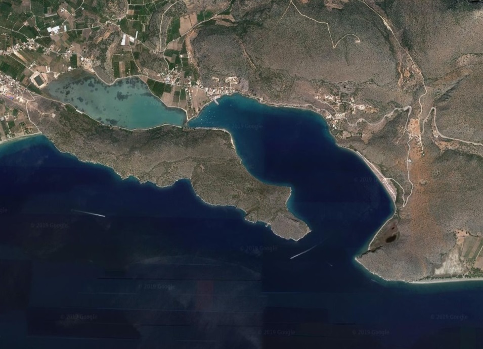
KOILADHIA
We next anchored off the
coastal village of Koiladhia in the large shallow bay of the same name on the
north-east side of the Argolic Gulf.

Anchored in
Koiladhia Bay
Khoiladhia is the seaport for
Kranidi, a significantly larger town three miles inland. It is a working and
fishing village with both inshore and offshore fishing fleets. There is the usual influx of Athenian summer
visitors, but when we visited the town was devoid of tourists.

Village of Koiladhia seen from anchorage
The large bay of Koiladhia has
a privately owned island at its entrance and is surrounded by hills. Holding is
good and the shelter is excellent. Boats are even left there on moorings all
year round.

Google Earth© view of Koiladhia Bay. The
boatyard can be seen
bottom centre in the process of its expansion

Private island at entrance to Koiladhia Bay
Traditionally, apart from
fishing, the village had a reputation for boat building in its shipyards. Today these have evolved into two very large
boatyards, which primarily support recreational boats, in terms of lift-out,
service and repair facilities. Security
looked excellent and there appear to be plans to expand the Basimakopoulos
yard. We calculated that the cost of
getting to and leaving our boat there would approximate to what we are paying
in LEROS. Food for thought.

Aerial view of
Basimakopoulos Boatyard: Photo
reproduced with permission of the management of Basimakopoulos Shipyard

Basimakopoulos Boatyard’s
100-ton lift with Koiladhia Bay and village behind
The village is best known for
the Franchthi Caves, which are prominent on the east coast of the anchorage.
Numerous prehistoric remains have been uncovered there.

Franchti Caves
viewed from anchorage
Khaidhari
Also known as Vivari or
Dhrepano, Khaidhari is located at the end of a long inlet under cliffs on
either side, making it a rather impressive natural harbour.
Google Earth© View of
Khaidhari’s well-protected bay
Most visiting yachts anchor
off the village, which appears primarily to be made up of holiday accommodation
and fish tavernas. The one and only quay
is dominated by fish farm supply vessels and local craft.

Village of Khaidhari,
also known as Vivari
At the other end of the bay, to starboard as one enters, is
a long, somewhat wild beach which attracts motorhomes and campers.

Motorhomes
free-camping on Vivari beach at the east end of the bay
Tolo
On our passage from Koiladhia,
we passed through the Tolo Strait, initially in a downpour and subsequently
through the wind acceleration zone created by Tolo island and the adjacent
coast. Once a small fishing village,
Tolo has developed into a tourist resort on the strength of its long sandy
beach and appears to attract package-holiday makers.

It was pouring with rain during the thunderstorm as we approached the
Tolo Strait

Making our way through the Tolo Strait
Nafplio
The large town of Nafplio lies
at the head of the Argolic Gulf. There are still a number of 18th-
and 19th-century buildings in the old town and along the waterfront. Outside the old town, 2- and 3-storey
purpose-built apartment blocks dominate.
Nafplio has for a long time been the most important city on the Argolic
peninsula.

Google Earth© view of Nafplio
The city and port are overlooked by two forts, the principal one being the Palamidi citadel. We started out early to climb the 1000 steps before the day grew too hot. The fort is said to be the most finely preserved piece of Venetian military architecture in existence. The views from it over the harbour and Argolic Gulf are outstanding.

View of harbour looking west with the Venetian citadel above and the
Bourtzi fort (once a prison; now a hotel) in the middle of the harbour

Venetian citadel of Palamidi which overlooks the city and harbour of
Nafplio

View from Venetian citadel of city and harbour of Nafplio
By the time we descended from the fort, the
city’s large Saturday fish and vegetable market was in full swing.

We’ve never seen a better fish and vegetable market
On our arrival in the port, an
individual dressed in a yellow hi-viz jacket insisted on taking our lines
(which we didn’t need him to do) and then demanding 10€ for doing so. When we refused to pay him, he threatened us
with and then summoned the Port Police. Since we refused to change our stance
on the grounds that he was a con artist (albeit a licensed one!) they appeared
to give him a lecture before demanding to see ALL our papers, which fortunately
are kept in order. It was slightly disconcerting
however when the senior policeman advised us to watch our backs since the ‘con
artist’ was a member of the local ‘Seamen’s Union’ which appears to be
‘running’ the port ‘Jack Jones’ style.
We later discovered that he’d conned 50€ from a large American motor
cruiser on one side of us and had requested 35€ from a large Dutch motor
cruiser on the other. The latter fortunately had been warned about him and
refused his ‘offer’ of help.
Suffice to say that we watched
the Rugby World Cup final between England and South Africa. We were obviously disappointed with the
result, but the better team on the day won convincingly. Fortunately we had retained the balance of
our semi-final winnings! We therefore
‘moved on’ and went out to lunch – this time to commiserate!

Taverna Omorfo,
Nafpoli Old Town, where we recovered after watching
England lose to South
Africa in the World Cup final
INLAND
TOUR OF ARGOLIC PENINSULA
We always appreciated that
Nafpoli was ideally situated to facilitate a tour of the historic interior of
the Argolic Peninsula. We hired a car on the Sunday to do so, in particular to
visit Mycenae and the Ancient Theatre of Epidavros. We were pleasantly surprised to find that on
the first Sunday of a month, museums do not charge an entrance fee!
Argos
Argos is the capital of the
Argolida province north of the head of the Argolic Gulf. The province is
primarily comprised of an enormous flat, fertile plain surrounded by high
mountains.

The Argolida
Province’s fertile plain covered with citrus orchards
Argos itself is a large
working town servicing the agricultural industries of the province. Larissa Castle, which overlooks the town and
plain, has magnificent views in all directions and was once a commanding
defensive feature in the landscape.

Larissa Castle
viewed from the streets of Argos town
MYCENAE
Mycenae at the north of the
province was the centre of the Mycenaen period, which succeeded the Minoans
(from Crete), and provided the material for Homer’s Epics. The two civilisations totally dominated
Greece, including Athens, during their periods in power.

The walls of the
Mycenae fort are made of massive masonry blocks
of some 100 cubic feet
constructed without mortar.
They are termed ‘Cyclopean’ since it was thought
that only
such giant figures could have built them

Commanding view
from Mycenae fort

The Lions’ Gate,
the main entrance to the fort
Mycenae itself has been
extensively excavated and has provided an enormous amount of information about
the civilisations of Ancient Greece.
Many of the site’s most important finds have been removed to Athens and
abroad, including the golden mask of Agamemnon.
The on-site Mycenae museum still houses excellent exhibits (including a
replica of the golden mask) that help one understand how advanced the
civilisation was.

The interior of
the Treasury building which housed the riches of the city.
It is of a remarkable ‘beehive’ construction

Excellent
presentations and explanations in the on-site Museum at Mycenae
EPIDAVROS
We particularly wanted to
visit the magnificent 4th-century BC theatre of Epidavros, renowned
for its perfect acoustics. It is in
remarkably good condition, due to the fact that it lay buried until the late
nineteenth century. It is now the venue for sell-out performances of Classical
Greek drama during July, as part of the Hellenic Festival. It can seat an audience of 12,000!

The Ancient
Theatre of Epidavros
OUR FORWARD PLANS
We plan to leave Nafplio
today (5 November) to make our way south down the east coast of the Argolic
Gulf and Peloponnisos, before returning across the Aegean to LEROS.
I hope Mike found a cheaper and less surly "Fish a la Spetsiosa" somewhere else. Was it nice, and have you a recipe?
ReplyDeleteExcellent overview of Peloponnese Tours! I love how this guide highlights the region's history, scenic landscapes, and authentic Greek culture. It's a valuable resource for anyone planning an unforgettable trip to Greece.
ReplyDelete